UTU Resources
The physical facilities listed below are available at the Department of Geography and Geology. Other departments at the University of Turku may host additional facilities that are used for geospatial purposes. The virtual resources are available for all the departments equally.
Laboratories
Geospatial research and education facilities include three different types of computer laboratories. All three laboratories are located at the Geography section in the Natura building.
1] GIS class (Paikkatietoluokka, room 420.1–420.2) is the largest computer laboratory at the Geography section. With the altogether 33 workstations for the students, it is the main teaching class used for a variety of undergraduate courses. The class is reserved mainly for teaching purposes.
2] Geospatial modelling lab (room 453) is intended solely for GIS, remote sensing and applied geoinformatics related research and education. The lab has five pc-workstations equipped with double screens and a stereo workstation with Planar stereo-monitor for image processing and advanced GIS analyses. Further information about the usage and reservation policy of the lab is found in the working instructions.
3] Maatila class (room 418) with 11 student computers is available for independent studying and data analysis as well as group working.
The most important desktop software packages for GIS (ArcGIS, QGIS) and Remote Sensing (Erdas Imagine, SNAP) are installed on all the UTU Geospatial Lab computers. The computers are also installed with statistical software SPSS and R.
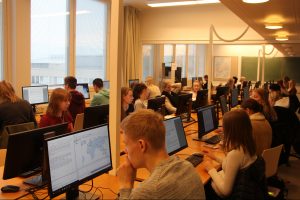
GIS class is the main teaching laboratory with 33 workstations.
Equipment
Besides the computer laboratories, the UTU Geospatial Labs hosts geospatial equipment and instruments utilised both in research and education. In addition, the researchers have access to the fieldwork facilities and instruments as well as the discipline specific equipment hosted by the Department of Geography and Geology.
The main geospatial instruments:
- RIEGL VZ-400 V-Line 3D Terrestrial Laser Scanner
- Two Trimble TSC3 controller and R8 GNSS receiver with GSM radio
- GARMIN Montana 680 GPS/GLONASS receivers
- Two drones: DJI Phantom 4 and DJI Matrice M210 V2 RTK with FLIR Zenmuse XT2 and Zenmuse X5S camera
As an indoor facility, the Geography section hosts an interactive touch screen that can be utilised in collaborative research and education. The 65” screen is fixed to a movable stand. Therefore, while the screen is primarily located at the Geospatial Modelling Lab, it can be easily utilised in other teaching premises as well.
- ClearTouch Interactive 6065U 65″ touch screen
The Department of Geography and Geology personnel can book the equipment in the reservation calendar hosted in the Maageo group in Microsoft Teams. Other UTU staff and students should contact the Geospatial Lab personnel for discussing the possibilities to utilise the facilities and instruments.
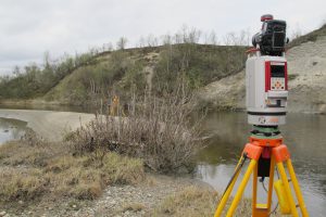
RIEGL VZ-400 V-Line 3D Terrestrial Laser Scanner in fieldwork in Lapland.
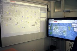
The ClearTouch Interactive 6065U 65″ touch screen (on the right) can be used for collaborative research and education.
Software (UTU-specific)
The University of Turku promotes open science. We encourage our researchers and students to use open source solutions in acquiring geospatial skills and competence. The open source programs and tools are open for all users and can be installed free of charge. Thus, they are freely usable also on the personal computers of students and staff. The most commonly utilised geospatial open source programs are:
CloudCompare is a 3D point cloud and mesh processing software. While it has been designed to perform comparison between two dense 3D point clouds, it also includes advanced algorithms for more generic point cloud processing tasks.
As free software, CloudCompare can be downloaded and installed free of charge on any computer.
QGIS is a professional GIS application with various built-in functions regarding spatial analysis, data management, data production, and visualization as well as database maintenance, and many more.
As open source software, QGIS can be downloaded and installed free of charge on any computer.
R is a language and software environment for statistical computing and graphics with an emphasis on geographical statistics modelling and map construction.
As free software, R can be downloaded and installed free of charge on any computer.
SNAP stands for Sentinel Application Platform, which refers to a common software architecture collecting free open source toolboxes designed for image processing of remote sensing data. SNAP is an ESA product, developed jointly by Brockmann Consult, SkyWatch and C-S. It supports several Earth Observation missions.
As an open source platform, SNAP can be downloaded and installed free of charge on any computer.
Besides relying on open source solutions, UTU utilises several commercial geospatial programs in its education and research efforts. The access to these products is UTU-specific though commercial licensing. The most important licensed software packages available at UTU are:
ArcGIS Pro is a full-blooded commercial data analysis software for hardcore analysis developed and maintained by ESRI. For example, it includes tools for data processing, management, visualization, automating workflows and creating 3D scenes. The smooth connection to ArcGIS Online enables the sharing of your maps online.
University of Turku has purchased a campus license of ArcGIS.
Erdas Imagine is a commercial software package aimed at remote sensing image processing developed by Hexagon Geospatial. This includes image pre-processing, such as geographic registration and stereo model production, image enhancement, radiometric correction, and visualization.
UTU Geospatial Labs has a license pool of 30 floating licenses.
MapInfo Pro is a widely used commercial GIS data management, storing, analysis, and visualization. It was developed by Pitney Bowes which is currently operating as Precisely.
UTU Geospatial Labs has a campus license with a floating license policy enabling installation on any computer at UTU.
For more information about the commonly used geospatial resources, visit the Software section of the Geoportti website that lists common geospatial software from desktop solutions to web services.
In addition to the more general geospatial tools, the UTU Geospatial Labs hosts a list of software designed for more specific tasks:
The Delft3D Flexible Mesh Suite (Delft3D FM) is a powerful modelling suite designed for hydrodynamical simulations on unstructured grids in 1D-2D-3D. It can be used to simulate, for example, storm surges, detailed flows and water levels, waves, as well as sediment transport and morphology.
UTU Geospatial Labs has several licenses.
eCognition is a remote sensing image processing toolset which utilizes automated object-based recognition of landscape patterns. It is developed by Trimble.
UTU Geospatial Labs has a license.
Fragstats is software originally developed by a development group at the Oregon State University. It is aimed at calculating landscape metrics from categorical raster datasets.
Fragstats is in the public domain and can therefore be freely distributed and installed on any computer at UTU and elsewhere.
Harava is a survey service for participatory design and community engagement. The map-based survey tool supports crowdsourcing and participatory planning. The platform is developed by Sitowise.
University of Turku has a license.
Maptionnaire is an online platform for creating map-based surveys enabling place-based data collection with citizens and other respondent groups. It is developed by Mapita Ltd.
University of Turku has a common license.
MOVE suite is a software package for geological 2D and 3D modelling developed by Midland Valley. Move offers advanced functionality in geomechanical, fracture, and sediment modelling and virtual cross-section development in desktop environment.
University of Turku has a pool of 20 floating licenses.
Pix4D is a photogrammetry software suite for drone mapping. The toolset can be used to convert images taken by drone or by hand into georeferenced 2D mosaics, 3D models, and point clouds. The suite also includes image processing and visualisation tools.
UTU Geospatial Labs has a license.
RiSCAN PRO is developed to be the companion software for RIEGL Terrestrial 3D Laser Scanner Systems. It can be used for processing, managing, and storing vast amounts of point cloud data.
UTU Geospatial Labs has a pool of 10 floating licenses.
Trimble Business Center is highly automated desktop software for various geospatial data processing. It focuses on GNSS, optical, and point cloud data set processing and maintenance with additional support for imagery such as aerial images.
UTU Geospatial Labs has a license.
Several software packages are available for installation across UTU. Both the students and the staff can download software from the UTUshop website (requires login). The UTUshop software catalog lists both the open source software and the products requiring campus licences. Software can also be downloaded for personal computers. UTU personnel can also utilise the Software Center to install software in their UTU computers. However, please note that the users are not allowed to install any software on the UTU geospatial lab computers without permission.