Equipment
Besides the computer laboratories, the UTU Geospatial Labs hosts geospatial equipment and instruments utilised both in research and education. In addition, the researchers have access to the fieldwork facilities and instruments as well as the discipline specific equipment hosted by the Department of Geography and Geology.
The main geospatial instruments:
- RIEGL VZ-400 V-Line 3D Terrestrial Laser Scanner
- Two Trimble TSC3 controller and R8 GNSS receiver with GSM radio
- GARMIN Montana 680 GPS/GLONASS receivers
- Drones: DJI Phantom 4 and DJI Matrice M210 V2 RTK with FLIR Zenmuse XT2 and Zenmuse X5S camera, DJI Mavic 3 Pro
- The Otter Uncrewed Surface Vessel (USV)
- Sontek RiverSurveyors
As an indoor facility, the Geography section hosts an interactive touch screen that can be utilised in collaborative research and education. The 65” screen is fixed to a movable stand. Therefore, while the screen is primarily located at the Geospatial Modelling Lab, it can be easily utilised in other teaching premises as well.
- ClearTouch Interactive 6065U 65″ touch screen
The Department of Geography and Geology personnel can book the equipment in the reservation calendar hosted in the Maageo group in Microsoft Teams. Other UTU staff and students should contact the Geospatial Lab personnel for discussing the possibilities to utilise the facilities and instruments.
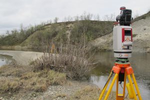
RIEGL VZ-400 V-Line 3D Terrestrial Laser Scanner in fieldwork in Lapland.
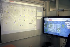
The ClearTouch Interactive 6065U 65″ touch screen (on the right) can be used for collaborative research and education.